


PRECINCT SUGARCREEK 151, Greene County, Ohio
About
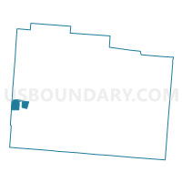
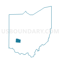
Outline

Summary
| Unique Area Identifier | 646731 |
| Name | PRECINCT SUGARCREEK 151 |
| County | Greene County |
| State | Ohio |
| Area (square miles) | 2.68 |
| Land Area (square miles) | 2.68 |
| Water Area (square miles) | 0.01 |
| % of Land Area | 99.75 |
| % of Water Area | 0.25 |
| Latitude of the Internal Point | 39.66908720 |
| Longtitude of the Internal Point | -84.09089650 |
Maps

Graphs
Select a template below for downloading or customizing gragh for PRECINCT SUGARCREEK 151, Greene County, Ohio


Neighbors
Neighoring Voting District (by Name) Neighboring Voting District on the Map
- PRECINCT BEAVERCREEK 019, Greene County, OH
- PRECINCT BEAVERCREEK 020, Greene County, OH
- PRECINCT BEAVERCREEK 021, Greene County, OH
- PRECINCT BEAVERCREEK 090, Greene County, OH
- PRECINCT BEAVERCREEK 093, Greene County, OH
- PRECINCT CENTERVILLE-G, Montgomery County, OH
- PRECINCT KETTERING 2-C, Montgomery County, OH
- PRECINCT KETTERING 2-G, Montgomery County, OH
- PRECINCT KETTERING 2-H, Montgomery County, OH
- PRECINCT SUGARCREEK 150, Greene County, OH
- PRECINCT SUGARCREEK 152, Greene County, OH
- PRECINCT SUGARCREEK 156, Greene County, OH
Top 10 Neighboring County Subdivision (by Population) Neighboring County Subdivision on the Map
- Washington township, Montgomery County, OH (56,607)
- Kettering city, Montgomery County, OH (55,696)
- Beavercreek township, Greene County, OH (52,156)
- Sugarcreek township, Greene County, OH (8,041)
- Kettering city, Greene County, OH (467)
Top 10 Neighboring Place (by Population) Neighboring Place on the Map
Top 10 Neighboring Unified School District (by Population) Neighboring Unified School District on the Map
- Centerville City School District, OH (56,638)
- Kettering City School District, OH (56,456)
- Beavercreek City School District, OH (53,697)
- Sugarcreek Local School District, OH (15,174)
Top 10 Neighboring State Legislative District Lower Chamber (by Population) Neighboring State Legislative District Lower Chamber on the Map
- State House District 70, OH (123,974)
- State House District 84, OH (116,799)
- State House District 38, OH (111,167)
Top 10 Neighboring State Legislative District Upper Chamber (by Population) Neighboring State Legislative District Upper Chamber on the Map
Top 10 Neighboring 111th Congressional District (by Population) Neighboring 111th Congressional District on the Map
Top 10 Neighboring Census Tract (by Population) Neighboring Census Tract on the Map
- Census Tract 2201, Greene County, OH (7,698)
- Census Tract 2202, Greene County, OH (7,553)
- Census Tract 2105, Greene County, OH (5,500)
- Census Tract 2104.01, Greene County, OH (4,964)
- Census Tract 216.02, Montgomery County, OH (3,359)
- Census Tract 402.03, Montgomery County, OH (2,734)